Course Information
Course map
The Paine to Pain Trail Half-Marathon is a single loop through the woods and trails of five parks in Westchester County. It starts and ends in New Rochelle, New York, 30 minutes north of midtown Manhattan.
Click on the course map to view/download a large, printer-friendly version.
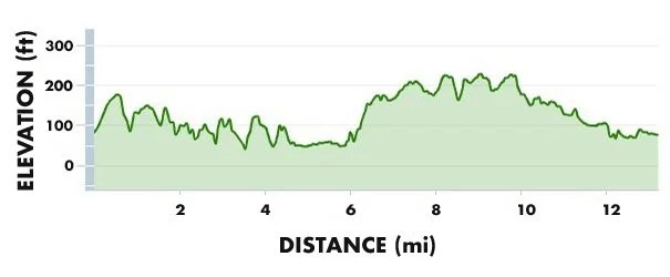
See below for an elevation chart of the course.
And this link should take you to a Google Map of the course.

Course description
Overview
Mid-pack runners should expect their time to be a minute per mile slower than road pace (~12%). The first half is more technically challenging than the second half, and will slow you down more than a minute per mile. If you’d like a real-life preview of the course, check out our annual Course Preview Run.
Staging area
Thomas Paine Cottage in New Rochelle. Check this map for parking. The stupid-easy taxi drop-off area is at the corner of North and Broadview. The drop-off, toilets, bib pick-up, water and baggage check are all within spitting distance of the actual start line. The race starts in multiple waves to avoid trail congestion. Do not park in our staging area or on the course or you will be tarred and feathered!
Mile 0.0 – 0.75
Each wave starts with a musket shot and a charge up Broadview Avenue through rows of high school cheerleaders, with a ½-mile climb at a 3.6% grade (100 feet in elevation). This hill, Thomas Paine's old farm, spreads out each wave before the first trail is entered.
0.75 – 3.6
Our first wooded area is the Leatherstocking Trail, the most technically challenging part of the course. This is a 2.8-mile linear park that is often rocky and hilly. This trail brings us past Larchmont and into Mamaroneck.
There are a number of wooden catwalks, some old and some new (including Paine Bridge), but all of which will be slippery with early morning dew. Single file only on the catwalks and stay in the center, as running on the sides can jar boards loose and create hazards for those behind you.
3.6 – 4.0
A short, steep uphill road (8% grade) connection (Rockridge Road –> Deerfield Lane) brings runners to Old White Plains Road and a small entrance to Saxon Woods.
The first water/aid stop is at the top of that hill. So you can drink while sucking wind. You're welcome.
4.0 – 6.0
After a twisty ¼-mile section of single track we built in 2005, we hit the main Saxon Woods trail and head right. (This deviates from the blue-star blazed Colonial Trail.)
The P2P trail loops around the southern part of Saxon Woods, over a stream, and through a boulder field.
We head north, parallel to Mamaroneck Avenue and the Mamaroneck River (seen down the slope to your right), along the park's eastern border, across a driveway to the park's pavilion and through a tunnel under the Hutchinson River Parkway. The Hutch bisects the park, dividing it into southern and northern halves.
6.0 – 7.5
The Hutch tunnel brings us to the northern section of the park.
We skirt the Saxon Woods pool and soccer field area (a prime spot for spectators due to easy car access), enter Scarsdale, and then head west into the heart of the northern section.
The 150-foot hill over rocky terrain is challenging. We exit the park by taking the trail next to the 18th fairway of the golf course. Listen for less talented golfers screaming in your direction in the event of a wayward tee shot. We like to think of this as a feature, not a bug.
The second water/aid stop is by the golf club house on Mamaroneck Road.
7.5 – 10.5
The race rejoins the blue-blazed Colonial Trail and heads southwest on the Hutchinson River Trail (our third park, an old bridle trail in the woods next to the southbound Hutch) through Scarsdale.
There's a stream crossing with stepping stones. The trails are now easier. As of April 2025 there were nesting bald eagles with eaglets by Lake Isle (10 mile-ish). So if you want to catch your breath, stop and look up. No yelling, please.
10.5 – 11.5
We cross an entrance/exit ramp for the Hutch (at Mill Road) and enter Twin Lakes Park in Eastchester. Our track will take us to the right onto a wide, dirt road in the woods abutting California Road.
The third water stop is just before the mile 11-ish mark, near the Twin Lakes stables. Please give a shout out to our Girl Scout volunteers. They might have a cookie for you.
11.5 – 12.5
After skirting a reservoir and passing through a second tunnel under the Hutch, at the Eastchester/New Rochelle border, we emerge into Nature Study Woods, our fifth and final park.
Much of this area was a former right of way for the New York, Westchester and Boston Railway. Some artifacts still exist in the woods. It's a popular running spot for students from nearby Iona University, New Rochelle High School, and your not-so-humble Race Director.
12.5 – 13.1
We exit the woods at Webster Avenue and Flandreau Road. The race finishes with a ¼-mile run down Flandreau, hopefully flanked by cheerleaders welcoming you home, entry into the football stadium at New Rochelle High School (McKenna Field), and a ¾-lap spin on the track.
Recovery and awards
Claim your medal, relax on the football field, eat real food, rehydrate, listen to live music, cheer on other runners and socialize, use locker rooms for toilets/showers, get a post-race massage, reclaim your baggage, work on your tan, take photos, kiss the Race Director, watch children race around, visit sponsors, and hang out for the awards ceremony.
Course elevation chart